by Lynn M. Moore, Botanist
Windom Floristics
November 28, 2006
Introduction
Townsendia glabella A. Gray is an endemic member of the Asteraceae, restricted to southwestern Colorado. There are documented occurrences of T. glabella in Montezuma, La Plata, and Archuleta counties. Townsendia glabella is rare throughout its limited range. There are 13 records in the University of Colorado Museum Herbarium (COLO), most of which were collected prior to 1940. One of these records is a specimen collected by Aven Nelson (Nelson #sn 1930) near the Mesa Verde National Park (MEVE) entrance.
The center of distribution for Townsendia glabella appears to be in Archuleta County, near Pagosa Springs, Colorado. There are only five records for the species in the Colorado Natural Heritage Program (CNHP) database, of which two are historic, from 1930 and 1941, two are unranked, and one is ranked A with 200 individuals (CNHP 2004b). An A ranked occurrence has the size, condition quality, and landscape context to be considered a population with excellent viability. This taxon is fully tracked by the CNHP.
 Townsendia glabella was re-discovered on private land adjacent to MEVE in 2004 by Peggy Lyon for the Nature Conservancy. Over 700 individuals were observed at that time. The population found in MEVE is the farthest known western occurrence and is an A ranked occurrence. The next largest documented population of this species was estimated at 200 individuals in Archuleta County. In 2005, Lyon discovered an additional occurrence near Pagosa Springs and she believes this occurrence to be the largest known population of T. glabella to date (Lyon personal communication 2005).
Mesa Verde National Park has negotiated a land acquisition that contains a portion of this population. The Nature Conservancy has been working with Mesa Verde National Park to acquire approximately 200 acres of the Henneman Ranch with the ultimate goal of adding it to the Park so that this species can be better protected from future threats of development. The landowners support the proposition. The Mesa Verde National Park Natural Resource Office needed to map and census this population in order to help support the land acquisition.
The purpose of this survey is to provide a more precise map of the location of this species within and adjacent to the MEVE NPS land boundary and provide an estimate of the numbers of individuals occurring in the target area.
Methods
This study is a species-specific intensive survey; therefore, all potential habitat within the area adjacent to the boundary between the Henneman Ranch land and the National Park Service (NPS) boundary was examined. Due to time constraints, only one day was available to conduct the field-work for Townsendia glabella. Inventory and mapping were accomplished by pedestrian surveys.
Documentation recorded several different kinds of information. All data was entered into a GIS/GPS data logger (Trimble GeoExplorer 3). Location data was recorded by satellite using Trimble GPS and supplemented with personal observations and directions when possible. Spatial data was differentially corrected. Habitat characteristics noted include aspect, elevation, landscape position, geologic formation, dominant tree cover, large fire history, soil characteristics, and vegetation cover (including tree, shrub, forb, grass, nonvascular, and bare ground). Slope was recorded using a clinometer at each of the sites at the point where the GPS position was taken and generally as a downhill measurement. It is expressed here in degrees and was recorded in 5 degree increments. Census data recorded at each site included a count (estimated if population was large and generally inaccessible to count accurately), species cover, area of census, reproductive status including numbers of individuals flowering, fruiting, vegetative, or present as seedlings. Additionally, invasive species and percent cover of each invasive was documented. Evidence of predation from mammal grazing or insects was also noted. Other possible threats noted include fungal attacks, drought, construction, erosion, or deposition.
Vegetation cover, species cover, and invasive cover were recorded using a modified version of Braun-Blanquet cover classes. Cover classes used in this inventory are R = rare (0-1 plant), 0 = <5% cover, 1 = 5-10% cover, 2 = 10-25% cover, 3 = 25-50% cover, 4 = 50-75% cover, and 5 = >75% cover.
Results
The results of the inventory yielded 18 occurrences located along the boundary between the Henneman Ranch and MEVE. Six of the occurrences were located on the Henneman Ranch and the remaining 12 were located on MEVE NPS lands. Four of the occurrences were relatively large and consisted of 100 or more individuals. Table 1 at the bottom of this page presents the ownership, occurrence ID number, and census data for the mapped locations. A total of 1,189 individual plants were estimated to occur in the target area. There are approximately 471 individuals located on NPS lands. The remaining 718 are located on the Henneman Ranch, including the largest occurrence in the survey area (ID #1).
Most of the observed individuals were either fruiting or flowering (250 with fruiting heads, 502 with flowers). The remaining 447 individuals were vegetative. Table 1 shows the reproductive status of the observed individuals present at each site. No seedlings were observed.
Habitat data collected at the site showed that Townsendia glabella is restricted to the Smokey Hill Member of the Mancos Shale (oyster bed). The 18 occurrences occurred either directly on the mapped formation or indirectly on the alluvium surrounding the oyster beds. This geologic formation forms a prominent oyster bench about 300 ft thick and approximately 900 ft above the base of the Mancos Shale. In the field, the soil type appears as a light colored small gravelly surface held together by a clay matrix in which ancient oyster shells can be discerned. The photo at left shows the Smokey Hill Member and the light colored gravel texture of the substrate.
The Townsendia glabella occurrences were all located on more or less gently sloping terrain. Most of the locations were on top of small ridges and a few of the occurrences were situated on the side of these hills. Slope was generally 0-5 degrees but varied up to 10 degrees. The individual plants were widely spaced and sometimes occurred along the sides of small shallow washes that drain the benches formed by the oyster beds. All but one of the occurrences were on south, southeast, to southwest facing slopes. The individual plants at ID #12 were facing north. Elevation was consistent across all 18 locations and varied 30 m (100 ft) from 2,119 to 2,148 m (6,950 to 7,050 ft).
The vegetation in the surrounding area consists of Piñon-Juniper woodland dominated by Piñon Pine and Utah juniper (Pinus edulis-Juniperus osteosperma). Area tree cover was estimated to be 10-25%. Associated shrubs include Gambel Oak (Quercus gambelii), Serviceberry (Amelanchier utahensis), and Sagebrush (Artemisia tridentata).
Townsendia glabella occupies openings within the Piñon-Juniper woodland. The photo at right shows the typical habitat of Townsendia glabella in MEVE. These openings are sparsely vegetated (50-75% bare ground) with widely spaced clumps of grasses and scattered forbs such as Indian Ricegrass (Oryzopsis hymenoides) and Squirreltail (Elymus elymoides subsp. elymoides). Typical forbs that are present in these openings include twin bladderpod (Physaria acutifolia), Fort Wingate milkvetch (Astragalus wingatanus), Alyssum sp., and Eriogonum sp. Occurrence numbers 9 and 10 were located close to the edges of the openings and one individual (ID #10) was rooted in duff beneath a juniper tree.
Discussion
The purpose of this report is to present the results of a species-specific survey of Townsendia glabella within a small, defined geographic area. The CNHP generates profiles for plants that are tracked. The profile discusses the taxonomy, conservation status, morphology, and habitat preferences for T. glabella. (Lyon, M. J. 2004a. This CNHP plant profile for Townsendia glabella is available by request from the Colorado Natural Heritage Program, Colorado State University, Fort Collins, CO.) Observations that would enhance the profile and are specific to MEVE are discussed below.
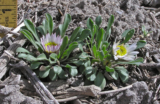
Townsendia glabella is a caespitose perennial with bluish-white ray flowers. It can be confused with T. incana, an abundant and common member of the genus. The two species can and do co-occur. Occurrence ID # 15 consisted of 10 plants that grew around and among T. incana. Townsendia glabella, despite its name, is not completely glabrous. It can have small, sparse hairs along the edges of the leaves and on the stems. The photo at right shows a T. glabella individual with small hairs along the edges of the leaves but there is no hoary, densely white pubescence giving the plant a cinereous appearance (ashy gray whitish color). The pubescence can be uniform and occur all over the stems and leaves. Additionally, the leaves of T. glabella are wider, more oblanceolate to almost spatulate in some individuals.
Townsendia incana is characterized by having copious amounts of hair on the leaves and stems, giving a cinereous appearance to the leaves and stems. The stems of T. incana in fact are very densely covered and it is difficult to see any of the stem surface if at all. The leaves of T. incana are narrower and more lanceolate in outline.
The observations of various levels of pubescence on Townsendia glabella indicates that possibly it is breeding with its more abundant counterpart and/or the natural variation within T. glabella is not fully understood. It has been speculated that these two species may hybridize (Lyon personal communication 2005). The photo at left shows the presence of hairs on the stem and leaves of a T. glabella individual. The surface of the stem is visible and it is not densely white hairy; nevertheless these hairs may cause some confusion in identification. The presence of these hairs may indicate some degree of cross breeding with T. incana. Additionally, Lyon’s 2004 survey along the west side of the main entrance road into the park revealed some individuals of T. glabella that consistently became more hairy and the leaves more narrow as the survey continued (Lyon personal communication 2005).
Townsendia glabella is restricted to the Mancos Shale in southwest Colorado. In MEVE, it is restricted to the Smokey Hill Member (oyster beds). The locations in Archuleta and La Plata County also occur on the Mancos Shale, but the specific member was not determined.
Townsendia glabella is known to occur with Ipomopsis polyantha, a United States Forest Service (USFS) sensitive species. During a species survey and monitoring project for I. polyantha numerous individuals of T. glabella were located in the Pagosa Springs area. It was during these surveys in 2005 that Lyon discovered a population of T. glabella that was significantly larger than the MEVE occurrence, consisting of thousands of individuals (Lyon personal communication 2005). A recent USFS Region 2 species assessment reported T. glabella as a common associate species of I. polyantha (Anderson 2004). The species assessment for I. polyantha did not report a specific member of the Mancos Shale where these two species co-occur.
The results of this survey showed a significant number of individuals of Townsendia glabella occurring on both the Henneman Ranch and on MEVE NPS lands. Because the population of T. glabella is essentially centered across both the Henneman Ranch and MEVE it would benefit the conservation of this species to place the entire population under MEVE protection. The land acquisition would consolidate the land holdings and ensure the protection of this rare endemic species. Further surveys of the Smokey Hill oyster beds within the Park would help to further define the extent of this population.
Acknowledgements
Windom Floristics would like to thank the Colorado Native Plant Society Myrna L. Steinkamp Fund for providing financial assistance in support of this project. Peggy Lyon of the Colorado Natural Heritage Program shared her field results and Susan Spackman Panjabi provided element occurrence ranking definitions. The Mesa Verde National Park Natural Resource Office provided permits, access information, and maps of the area. George San Miguel provided valuable support in procuring the funding and specific information about the land acquisition. Much gratitude goes to Marilyn Colyer of the Natural Resource Office for sharing her knowledge of the geology and habitat information for Mesa Verde National Park. Thank you to Jan Loechell Turner for reviewing the report.
Table 1 Townsendia glabella survey results, including occurrence number, land ownership, count, size of occurrence, species cover class, and reproductive status.
The Research Grants Committee thanks the many Colorado Native Plant Society members and Committee supporters for their donations to the research grants funds. Your donation to these funds is encouraged and welcomed. Please make your check to the Colorado Native Plant Society, designate the fund(s) to which you are donating and mail to:
Treasurer
Colorado Native Plant Society
P.O. Box 200
Fort Collins, Colorado 80522
Please contact Jan L. Turner for more information